Wednesday, April 30, 2014

FROM ONE VALLEY OF FIRE TO ANOTHER, AND BEYOND

Once we've decided we're moving along, we move along. From the Valley of Fires National Monument in New Mexico, we went - via Kaibab National Forest - to Valley of Fire State Park in Nevada. We stayed in a fabulous campsite (#28, in the non-hook-up campground) and thought that we might stay and do some hikes and see some of fascinating rock formations. But once we decide to move along...we do!

So we packed up and hit the trail towards Walker Lake (still in Nevada), and we made it! Before dark even!
This tree is growing right out of the volcanic rock at Valley of Fires
One last look at the lava beds at Valley of Fires
Our campsite at Valley of Fire in Nevada
Our camp chairs next to a huge, flat rock formation
Climbing a bit up the rocks behind our site
Weird holes, arches, and strange shapes abound in the formations
Different view from campsite #28
View down from the rocks behind the site
Wildflowers in bloom amongst the rocks (yes, right at our campsite!)
When we left Valley of Fire, we took the Extraterrestrial Highway (through area 51) and saw these guys. They seemed friendly, but we were in a hurry, so we didn't stop to chat.
We made it to Walker Lake just before sundown
Yes, that's snow on the far mountain tops, and teeny Darell in shorts

Monday, April 28, 2014

LONG DAY OF DRIVING

After trying to move north through New Mexico, and encountering gusty winds and low overnight temps (there is a cold snap occurring throughout central and northern New Mexico for the next week and a half), we've changed course. We got up this morning and decided to just drive westward, instead of waiting around in New Mexico for the freezing temperatures to go away. We drove all the way to Flagstaff, Arizona, and then pushed on to the next city, Bellemont, where there was a Pilot Truck Stop where we might stay. Couldn't find a space at the Pilot, so we headed for a rest area a bit further along I-40. The exit was barricaded; Rest Area was closed. The next city was Williams, and we pulled off to check the maps and see where we might sleep - it was already dark. We set out for a Forest Service campground nearby, but got lost and ended up in a different part of the Kaibab National Forest. No campground, but dispersed camping is allowed here, so we just pulled off the dirt road and pulled down the shades! Day is done!

Sunday, April 27, 2014

VALLEY OF FIRES

I was totally wrong about the lava flows here! They aren't the result of an erupting volcano (as previously posted), but rather lava coming up through holes in the ground called "vents."  The swath of black rock extends for 44 miles, with widths ranging between 2 and 6 miles. At the deepest part, it is 165 feet deep! The campground is right on the edge of the flow area, and there is a short, accessible nature trail that takes you through part of the area. Today the wind is forecast to be about 30 mph, with gusts up to 65! Fortunately, we hiked the trail before the winds really got going! It's also really cold here; we had to dig out the knitted sweaters!
Interesting shapes, cliffs, holes, and ridges abound

Flowers will bloom, even in this barren landscape


This view is towards the campground - that's our Chinook on the ridge

Weird, ripple-y lava flow

More ripples
Some cracks

A 400 year old juniper tree

Can't have a blog post without cactus blossoms, can I?

A long view

Cracks and ripples

Ripples and cracks

The indomitable flower spirit

More oddly-textured rocks

This is the view away from the lava beds, from our campsite. Those distant mountains were completely obscured by dust yesterday; the wind changed direction this morning, blew the dust away, and there they were!

Saturday, April 26, 2014

CLOUDCROFT ON HOLD, JUST TOO DARN COLD

Well, our plans to spend a few days hiking in Cloudcroft have been shelved due to the fact that they are predicting snow there. Enough said. Instead, we've just pulled into the campground at Valley of Fires (now that sounds warmer, doesn't it?) Recreation Area. It is an area where a volcano erupted about 5,000 years ago, and the terrain is black and craggy - very different from the rest of the terrain that surrounds the 6-mile swath of lava flow. Unfortunately, the wind speeds here are upwards of 40 mph, so mostly we are just sitting inside listening to the whistling wind, and experiencing the tossing of the Chinook with each big gust! The dust in the air is so thick that visibility is severely impaired. But it is warm (72 degrees) and the internet connection is good! Also, the bathrooms have hot water, soap, and paper towels!

Thursday, April 24, 2014

SPRING HAS SPRUNG

The cactus blossoms are becoming profuse now - the masses of buds are opening into full flowers, in yellow, orange, pink, and rust:


And here's a photo of me in my new National Solar Observatory T-shirt:


Wednesday, April 23, 2014

A REAL DESERT BUNNY

 I saw this bunny hopping across the road at the campground, then pausing, still, under some brush:


Tuesday, April 22, 2014

WHITE SANDS NATIONAL MONUMENT

The White Sands National Monument is the site of a fascinating geological phenomenon, where gypsum crystals from eons ago have broken down into smaller and smaller bits until they qualify as sand, and have piled and shifted and drifted, like snow, to form dunes for miles. Some parts of the area have vegetation that has adapted to live in the ever-changing environment, and some parts are just white sand mountains. You can buy sleds to slide down them, you can hike trails through the low parts of them, or you can just take in their majestic beauty.
The Visitor's Center is informative, and busy!
A view from the top of a dune we climbed (which was a challenge because of the soft sand)
The sky was full of the most magnificent clouds!
Darell (not teeny this time!) up on top of the dune. Footprints in the foreground were gone within seconds, due to the high winds moving the sand constantly
It looks just like snow!
This is a photo of the dunes when the sun went behind a cloud - you can see more definition when the dunes are in shadow

Monday, April 21, 2014

CLOUDCROFT, NM AND THE LINCOLN NATIONAL FOREST

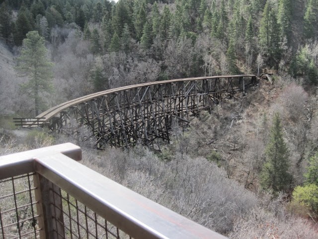
Drove up to the little town of Cloudcroft, NM (about 17 miles from Alamogordo) and visited the Lincoln National Forest Ranger Station and surrounds today. We went from about 4,000 ft. in elevation to 8,000+ elevation in only 17 miles. The terrain changed from desert to mountains with tall trees, green meadows, and running creeks (tiny ones, but creeks nonetheless!). The town is a quaint resort town (the major trade being hiking in Spring, Summer, and Fall, and skiing in Winter), with a community ice skating rink, little shops, restaurants, and a bakery where we bought a loaf of garlic bread that contained whole roasted cloves of garlic (for me) and a chocolate croissant (for Darell). Interestingly - to us anyway - Darell's grandfather was born in Cloudcroft in the early 1900's. It is a town that was built on logging, and train tracks to move the timber. It also hosted a children's TB sanitarium in the 1920's. The last train left in 1947, but hiking trails mark where the tracks used to be, and ruins of trestles are still visible. They've even reconstructed one trestle so the public can see what it had been like. The Ranger Station was one of the best we have encountered, and the staff was really helpful with maps and info. A nice bonus to our day was the discovery of the National Solar Observatory, along the Sunspot Scenic Drive: An absolutely wonderful visitor's center offered a fascinating look into the scientific research that is done there by a consortium of many different organizations and universities, including University of Washington, Johns Hopkins, New Mexico State, and others. I even bought a t-shirt.
This is the overlook to the Mexican Canyon Trestle

The trestle, as reconstructed
This is a view from a short hike we took off the main road - that white layer at the horizon is the White Sands National Monument
A little spring-fed stream that led to a small waterfall at Bluff Springs, where we may camp next week
Check out the ears on this deer - taxi cab with the doors open, eh?
At over 9,250 ft. elevation, the view from the Apache Point Observatory was striking - dare I say it was the high point of our day?

Sunday, April 20, 2014

Saturday, April 19, 2014

THE CLOUDS ARE LIFTING

It's been a bit stormy here, both yesterday and today. We've had a little thunder, a little lightning, and a few spits of rain, so we've been hanging out indoors lately. But the clouds are lifting now...

Thursday, April 17, 2014

PUT ME ON THE NO-FLY LIST

Today we hiked the Dog Canyon Trail, out as far as the Line Cabin, ruins of a stone cabin at the box end of the canyon. It was a strenuous, steep hike totaling about 6 miles, with a 1,500 foot elevation change. We haven't been doing many longer hikes lately, so it was quite the challenge. The real challenge, however, was putting up with the flies! The little horrors were more concentrated along certain parts of the trail, but they were annoying almost everywhere, and we had to eat our picnic lunch as we hiked, waving our cheese sandwiches all around like windmills, because if you stop, they land.

This is part of the steep ascent that makes up the first part of the hike
Part of the way up the ascent
Teeny Darell ahead of me on the trail
A view from along the trail - teeny Chinook is the white dot just to the left of the yucca spike, along the campground road
After reaching a grassy mesa, we then descended a bit into the canyon where the cabin ruins are. This is the end of the canyon, where the water flows down the rocks alongside the cabin site.
A grinding stone near the cabin ruins (and a little cactus starting to bloom on the rock in the background)
Teeny Darell on the way back down the trail, stopping for a view of the White Sands along the horizon
Flora and fauna (reptiles and insects, anyway) along the trail:
The lizards here are bigger than we've seen elsewhere; this one was about 10 inches long
Prickly Pear Cactus buds
Blossoms, and Bees, and Buds, oh my!
This lizard was only about 6 inches long, but what a colorful chap!
A wildflower
These plants are blooming everywhere here right now
I didn't know the bee was there when I took the photo!